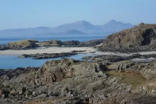
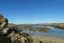
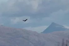
A walk to a beautiful beach on the Ardnamurchan peninsula with fabulous views of The Small Isles and Ardnamurchan Point. The beach is fabulous with white sands and clear turquoise seas, with an abundance of shells on the strand line. Look out for raptors, including golden eagle…
Walks in Ardnamurchan, Moidart, Sunart, Ardgour and Morvern
Discover the wild side of Ardnamurchan with our wildlife focused walks on The Ardnamurchan Peninsula, Moidart, Sunart, Ardgour and Morvern on The West Coast of Scotland. Ardnamurchan offers a selection of walks for all abilities with great opportunities for wildlife watching and stunning scenery. See individual walking pages for OS maps and route descriptions.
- Ardnamurchan and Moidart Walks
- Arisaig, Mallaig and Glenfinnan Walks
- Fort William and Glen Nevis Walks
- Glencoe, Loch Leven and Argyll Walks
terrain: grassy path and beach
grade: easy
length: 2.6km (1.6 miles) or less
grid ref:
type: there and back
terrain: moorland path, track and road
grade: easy
length: 5.5km (3.4 miles)
grid ref:
type: circular
A circular walk starting in the village of Portuairk, up through the hills and along to beautiful beach at Bay MacNeil and back along single track road and woodland.
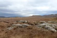
This is a lovely coastal walk through some fine stretches of heathland and upland grassland, with some stunning coastal…
![]()
terrain: gentle hills and beach
grade: moderate
length: 6.6km (4 miles)
grid ref:
type: lollipop
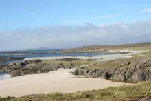
A fantastic walk to the beautiful white sandy beaches of Sanna bay on the Ardnamurchan peninsula, with the option of extending the walk to the hills beyond the dunes. The walk affords amazing views of Ardnamurchan Point and the Small Isles, as well as providing the opportunity to explore…
![]()
terrain: woodland and moorland path - boggy
grade: moderate
length: 2.4km (1.5 miles)
grid ref:
type: circular
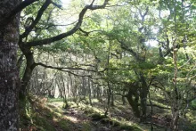
A little gem of a walk through hazel woodland to open heathland offering a real taste of wild Ardnamurchan. A great short and highly rewarding walk, providing an opportunity to explore some fine wood and open habitats and, if lucky, encountered some iconic species. There are…
![]()
terrain: track and boggy path
grade: challenging
length: 9km (5.6 miles)
grid ref:
type: there and back
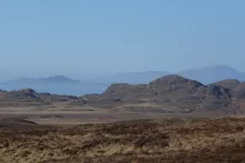
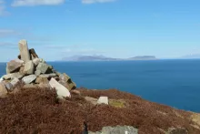
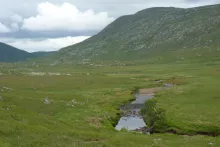
A stunning walk affording panoramic views of a volcanic ring dyke and caldera, the remains of an ancient volcano on the Ardnamurchan peninsula. The walk also offers an opportunity to explore the deserted village of Glendrian (option 1) and as well as a more challenging route (option 2) to…
![]()
terrain: track and field
grade: easy
length: 1.2km (0.75 miles)
grid ref:
type: there and back

A short walk to admire the remains of the chambered cairn, Greadal Fhinn, on the summit of a knoll at Ormsaigmore on the Ardnamurchan peninsula. The Neolithic cairn contains two chambers, a larger passage grave on south-eastern edge of the mound and a smaller central cist. Most of the cairn…
![]()
terrain: boggy path
grade: moderate
length: 7km (4.4 miles)
grid ref:
type: there and back
A lovely walk along a glen from Fascadale Bay to the shingle inlet of Port Eigin-aig on the Ardnamurchan peninsula, with good chances of seeing raptors and red deer.
There are some lovely views of the surrounding low hills of the Glen, dominated by Meall an Fhir-eoin and the surrounding…
![]()
terrain: grassy path
grade: easy
length: 1.4km (0.9 miles)
grid ref:
type: there and back
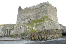
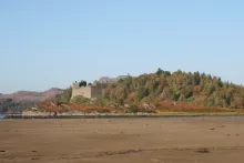
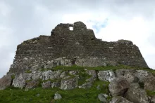
Please note as of 2013 access to Mingarry Castle is not possible due to restoration work.
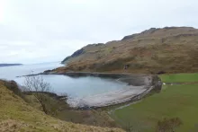
A short walk to Mingary Castle and to a lovely rocky shoreline and shingle beach. The route heads through rough grassland/pasture, and affords good views of Ben Hiant and Beinn…
![]()
terrain: grassy path and track
grade: easy
length: 1.6km (1 mile)
grid ref:
type: there and back
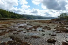
A short walk to Kilmory Beach on the Ardnamurchan peninsula, a lovely sheltered sandy beach on the north coast of the Ardnamurchan peninsula. The beach is punctuated by numerous rocky outcrops of heavily jointed igneous rocks, and fringed with green and purple hued boulders and shingle.…
![]()
terrain: grassy path
grade: moderate
length: 4.4km (2.75 miles
grid ref:
type: there and back
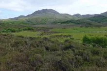
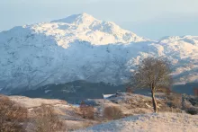
The austere rugged profile of Ben Hiant (528m) dominates the northern shore of Loch Sunart of the Ardnamurchan peninsula with its bare rock exposures and jutting outcrops.
Ben Hiant epitomises the complex geology of the Ardnamurchan region being a conglomeration of quartz-dolerite,…
![]()
terrain: track and path
grade: moderate
length: 15.8 km (9.9 miles)
grid ref:
type: there and back
This is a stunning walk across a wild rugged terrain to a beautiful beach. The walk passes through heathland with some stunning coastal and hill views, with particularly fine views to the Small Isles, Mull and Skye. Gortenfern beach is lovely sandy beach and a great place for…
![]()
terrain: path and field
grade: moderate
length: 2.6km (1.6 miles)
grid ref:
type: there and back
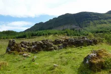
An interesting walk to the small halmet/clachan of Bourbliage located on the southern shore of the Ardnamurchan peninusula on the south-east flank of Ben Hiant, between Camus nan geall and Macleans' Nose. The settlement occupies a 14 acre site, between 100 and 150 metres above sea level and lies…
![]()
terrain: path and track
grade: easy
length: 3.2km (2 miles)
grid ref:
type: there and back
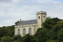
A lovely walk to the small remote chapel of St Columba on the Morvern peninsula. The impressive cream rendered chapel with its attractive stonework and distinctive battlemented tower is perched on raised ground overlooking the Sound of Mull.
There are some lovely coastal views at the start…
![]()
terrain: path, track and shingle beach
grade: moderate
length: 5.4km (3.4 miles)
grid ref:
type: there and back
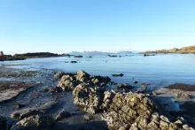
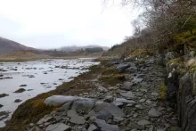
An interesting walk along the rocky shore line from the inlet at Camus nan Geall on the Ardnamurchan peninsula. The fertile ground on Camus nan Geall has a long history of settlement as evidenced by an ancient chambered cairn and standing stone. The site has also served…
![]()
terrain: path with steep ascent/descent
grade: moderate
length: 2.6km (1.6 miles)
grid ref:
type: circular
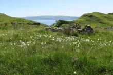
Glenborrodale on the Ardnamurchan peninsula is the RSPB’s most westerly reserve and managed for its oak woodlands. This is a pleasant walk through deciduous woodland onto heath/moorland on the north shore of Loch Sunart, with excellent views over Loch Sunart.
A good spot for raptors…
![]()
terrain: rough track, boggy
grade: moderate
length: 6.5km (4 miles)
grid ref:
type: there and back
A pleasant walk along a rough/coastal path to the ancient crofting village of Smirisary in Moidart and onto the silvery sands. Good views over the Bay of Arisaig and to the Small Isles. The species-rich coastal grassland, the sandy shell beach and clear blue seas make it an ideal spot for…
![]()
terrain: mainly forest track
grade: moderate
length: 9.8km (6.2miles)
grid ref:
type: there and back
An enjoyable walk to the beautiful Singing Sands at Gortenfern in the Ardnamurchan, skirting around the southern edge of Kentra Bay and then through coniferous plantation. Kentra Bay contains a large expanse of mudflat at low tide and small fragments of salt marsh, sand dune and machair.…
![]()
terrain: track
length: 4.6km (2.9 miles)
grid ref:
type: there and back
An easy and enjoyable walk from Castle Tioram at Dorlin along the banks of the River Shiel with good opportunities for spotting wildlife.
The walk gives an opportunity to enjoy heathland, woodland and coastal habitat. At low tide the large sandy beach by Castle Tioram is a good place…
![]()
terrain: rough track - vertiginous in places
grade: moderate
length: 6.1 km (3.8 miles)
grid ref:
type: circular
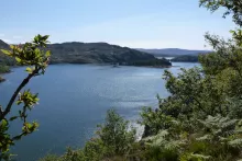
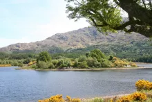
A very pleasant and interesting walk through woodland, heathland, moorland and along coastal tracks with stunning views over Loch Moidart with its many pine clad islands and Castle Tioram.
The route follows small water courses lined with mainly alder, birch, ash, willow and ash; the trunks…
![]()
terrain: woodland path
grade: moderate
length: 1 km (0.8 miles)
grid ref:
type: there and back
A stunning walk to the vitrified iron-aged fort at Shielfoot Torr. A secret journey through ancient oak woodlands to the knife edge ridge with stunning views over The River Shiel and beyond.
The route to the fortifactions on Shielfoot Torr passes through some lovely deciduous ancient…
![]()
terrain: Road and path
grade: easy
length: 8km (5 miles)
grid ref:
type: there and back
An easy walk along a private road on the North side of Loch Teacuis with an optional foray further along the side of the loch. The private road meanders through farmland, along the northern shore of Loch Teacuis and through Atlantic oak woodland to Rahoy House. Good opportunities to…
![]()
terrain: open hillside
grade: moderate
length: 2.6km (1.6 miles)
grid ref:
type: there and back
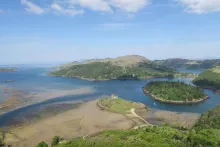
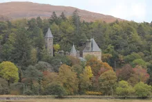
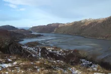
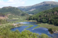
This amazing viewpoint overlooking Castle Tioram and Loch Moidart is just a short diversion from the Blain Burn or Castle Tioram Circular walks and well worth the effort for some amazing views and photographic opportunites. There are several routes up to the viewpoint, though we find this…
![]()
terrain: track and road
grade: moderate
length: 6.9km (4.3 miles) with optional shortcuts
grid ref:
type: circular
A circular walk on track and road across Kentra Moss with good opportunities for botanising and bird watching. Kentra Moss, together with nearby Claish Moss, is one of the few examples of eccentric mires in Britain being a fine example of oceanic blanket bog.
The walk provides…
![]()
terrain: track and path
grade: moderate
length: 6.4 km (4 miles)
grid ref:
type: circular
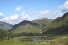
A lovely walk through woodland and then out onto open heath, skirting around the edge of Blain lochan with good views of the surrounding hills of Beinn Gheur and Beinn Bhreac and stunning views over Loch Moidart to the Small Isles. There is an opportunity to…
![]()
terrain: forest and grassy paths
grade: moderate
length: 3.4km (2.1 miles)
grid ref:
type: circular
An interesting circular walk to explore the deserted township of Aoineadh Mor (pronounced Inniemore). There are three walks (Mary’s Path, James’s path and the Township Path) that can be combined into a circular trail. James and Mary’s path pass mainly through mixed pine…
![]()
terrain: Forest track
grade: easy
length: 12 km (7.5 miles)
grid ref:
type: there and back
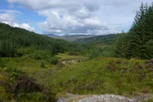
A lovely walk through mainly coniferous woodland on a forest track with some fine glimpses of Ben Resipol on route, and of Loch Shiel towards the end of the track. There is an optional detour to the edges of Claish Moss approximately 2 miles from the start of the walk.
The forest…
![]()
terrain: path, vertginous in places
grade: moderate
length: 3.6km (2.2 miles)
grid ref:
type: circular
A pleasant, scenic walk and interesting walk along the old track on the north side of Loch Moidart that formerly connected Glenuig and Kinlochmoidart. There are excellent views of Loch Moidart on route.
The area has a long history and turbulent history of occupation,…
![]()
terrain: track
grade: easy
length: 7.4km (4.6 miles)
grid ref:
type: there and back
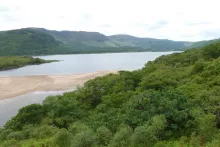
This is a lovely walk along a tarmac track by the shores of Loch Aline through coastal deciduous woodland, affording some lovely views of the loch, surrounding hills and Ardtornish House.
The coastal woodland is stunning composed of hazel, ash, sycamore, alder, beech, rowan, elm, oak…
![]()
terrain: woodland track
grade: easy
length: 1.7 km (1.1 miles)
grid ref:
type: circular
An interesting and enjoyable way-marked circular woodland walk through a lovely section of Atlantic oak woodland on the northern shore of Loch Sunart, with good coastal views of Salen Bay and Loch Sunart.
The path is way marked and well defined, with a few small ascents and descents…
![]()
terrain: track and path
grade: easy
length: 1.5-3km (1-2 miles)
grid ref:
type: lollipop
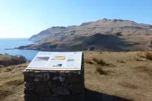
The Salen Alphabet Trail provides an interesting introduction to the importance of nature and plants to the Gaelic culture. The information boards in the car park introduce the Gaelic alphabet which has eighteen letters, each of which is associated with a species of tree. …
![]()
terrain: woodland path
grade: easy
length: 0.7km (0.5 miles)
grid ref:
type: circular
The Bay of Flies, near Salen in the Ardnamurchan is a natural harbour formerly used to export goods, such as charcoal, oak bark and brushwood. The Viking's were also reputed to have stored their boats over winter in the harbour. The short, circular walk descends along a well-defined path…
![]()
terrain: track and undefined path
grade: moderate
length: 5.8km (3.6 miles)
grid ref:
type: there and back
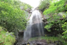
An interesting walk to a an impressive waterfall, named in honour of Alfred, Lord Tennyson who was a regular visitor to Old Ardtornish House in the 19th century. The route follows a track along the shores of Loch Aline, passing by an old lime kiln, before ascending the lower flanks of Goirtein…
![]()
terrain: path, track and road
grade: moderate
length: 3km (1.9 miles) and 2.6km (1.6miles)
grid ref:
type: circular
The Prince's Walk is an interesting circular walk through the grounds of Kinlochmoidart estate and woodlands (marked red on the map). The walk is named after the association of the original house with the 1745 uprising in support of Princes Charles.
The route…
![]()
terrain: rough path - boggy in places
grade: moderate
length: 4.5km (2.8 miles)
grid ref:
type: there and back
A walk through oak woodland and heathland along the shores of Loch Arienas to the deserted village of Arienas in the Scottish Wildlife Trust Rahoy Hills Reserve. The Rahoy Hill Reserve is designated as a Site of Special Scientific Interest.
Look out for golden eagle, buzzard,…
![]()
terrain: track
grade: easy
length: 8km (5 miles)
grid ref:
type: there and back
An easy walk along a good track into the hills and wilderness behind the Scottish Wildlife Trust Rahoy Hills Reserve along the banks of the Black Water River.
There are excellent views on route of the surrounding hills of Braigh Uladail to the east and Meall Achadh a’ Chuirn and Monadh…
![]()
terrain: road and track
grade: easy
length: 13.4km (8.4 miles)
grid ref:
type: there and back
An easy walk along road and track to the ruins of Ardtornish Castle on The Morvern Peninsula.
The walk provides a wonderful opportunity to explore a ruined castle and affords fabulous views over Loch Aline and the Sound of Mull. There are also some lovely mixed deciduous woodland on route…
![]()
terrain: mixed
grade: moderate
length: 12.6km (7.9 miles)
grid ref:
type: there and back
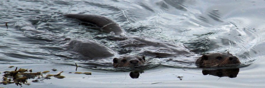
A lovely, but fairly strenuous, and long coastal walk along the shores of Loch Moidart, with the possibility of seeing otters and a range of coastal birds. The walk is a ‘there and back’, although parts of the Silver Walk are incorporated into other routes, namely Blain Burn and…
![]()
terrain: forest and moorland track
grade: moderate
length: 3.3km (2 miles)
grid ref:
type: lollipop
A magical woodland walk through coniferous plantations to the hills beside Loch Moidart. This is a fairly strenuous, circular walk through mainly coniferous woodland into the hills, with some steep ascents on well defined paths. Excellent views afforded over Loch Moidart to the…
![]()
terrain: mountain track
grade: challenging
length: 16km
type: there and back
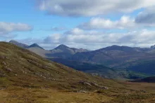
Ben Resipole, a Corbett, is the highest peak on the Ardnamurchan, and affords spectacular views of Loch Shiel, Loch Sunart, the Small Isles and Skye on a clear day. The route is strenuous and the path is muddy and indistinct in places. However, the walk is enriched by the changing…
![]()
terrain: track
grade: moderate
length: 4.4km & 8.3km (1.4 & 5.1 miles) there and back
grid ref:
type: there and back
A starting point for two very pleasant walks-Dalilea to the Green Isle walk, and the Dalilea to Kinlochmoidart walk.
The Green Isle Walk
The Green Isle Walk is a short pleasant walk along a track along the shores of Loch Shiel through rough grassland and…
![]()
terrain: track
grade: moderate
length: 5.2km (3.2 miles)
grid ref:
type: there and back
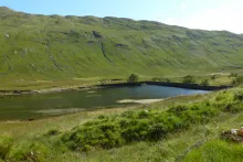
An enjoyable walk following a gravelled track with good views of the hill lochan, Loch nan Lochan, and ascending to the reservoir at Glen Forslan. Fine hill scenery and the picturesque falls of Glenforslan make this a very pleasant walk. In addition, devil's bit scabious (Succisa…
![]()
terrain: track - steep in places
grade: easy
length: 1.5km (1 mile)
grid ref:
type: there and back
An occasionally steep, but well surfaced, gravel path meandering through native woodland from Ardery to the Garbh Eilean Wildlife Hide. The walk takes you through oak and birch woodland with an understory of mainly heather and bilberry (Calluna vulgaris, Vaccinium spp and …
![]()
terrain: Forest track and path
grade: easy
length: 4.75km (3 miles)
grid ref:
type: lollipop
A pleasant walk in the Glenhurich Forest mainly along a forest track from Polloch, near Strontian, to the shores of Loch Shiel. The route passes through coniferous plantation, heath, and woodland. There are two viewpoints on route providing fine views across Loch Shiel whose restless waters…
![]()
terrain: track and path
grade: easy
length: 7.6km (4.7 miles)
grid ref:
type: there and back
A lovely walk through plantation and heath to the remains of the Corrantee Lead mines and beyond. The route follows a watercourse for some of its way and affords some spectacular views of the surrounding hills of Ardnamurchan, Sunart, Moidart and Morvern. A great walk for views and…
![]()
terrain: path, track and road
grade: easy
length: 7.7km (4.8 miles)
grid ref:
type: circular
A lovely circular walk over moorland, woodland and along the banks of the Strontian River to Scotstown and Ardnastaing. The walk provides a good opportunity to enjoy the fauna and flora associated with deciduous and coniferous woodland, heath land and riparian habitats. The ground…
![]()
terrain: track and path (boggy in places)
grade: moderate
length: 11.4km (7.1 miles)
grid ref:
type: there and back
The Corrantee Lead Mine is the most westerly of the mines around Strontian and can be reached from either Polloch or Strontian on the old coffin route. The path over the hills is well defined and affords some excellent views over the craggy hills of Sunart and Ardgour. The walk from…
![]()
terrain: path, track and road
grade: easy
length: 6.9km (4.3 miles)
grid ref:
type: circular
A varied walk with some lovely sections along the banks of the Strontian River, the surrounding hills and through the Community Woodland at Strontian. The Community Woodland is a policy woodland, planted by the Riddle family in the 1800s as a symbol of wealth and importance. It…
![]()
terrain: woodland path
grade: easy
length: 1.5km (1 mile)
grid ref:
type: circular
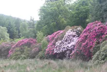
This is a lovely magical short walk through a former policy woodland. The woodland was planted by the Riddle family in the 1800s and boasts over 60 exotic and native species of tree, including firs, spruces and pines, as well as a range of fine specimen deciduous trees. There is a…
![]()
terrain: Forest and moorland track
grade: moderate
length: 10-11 km (6.5 miles)
grid ref:
type: lollipop
The Ariundle National Nature Reserve is a lovely place to visit at any time of the year, and there are two lovely walks through the woods and hills. The Reserve is a fine example of ancient coastal Atlantic oakwood and is recognised for its old oaks supporting a huge diversity and…
![]()
terrain: track and path
grade: moderate
length: 4km or 5.75 km (2.5 or 3.6miles)
grid ref:
type: circular
A pleasant walk through coniferous plantation and into the hills around Kingairloch. The walk passes by some unroofed sheiling huts and an abandoned settlement.
Larch, pine and spruce plantation support an understory of bryophytes, including Common Tamarisk-moss(Thuidium…
![]()
terrain: track
grade: easy
length: 3.2 km (2 miles)
grid ref:
type: there and back
A walk along a track following the banks of meandering Glengalmadale River to Glen Galmadale Dam with its fish ladder. There are lovely views of the surrounding high ridges, with the peaks of Beinn na Cille, Fuar Bheinn, Creach Bheinn, Maol Odbar, Meall nan Each dominating the…
![]()


